

Abnormal start to fall for southeast Wisconsin with fluctuating temps, heavy rain
SOUTHEAST WISCONSIN -- On Oct. 1 and Oct. 2, a majority of Wisconsin was dealing with a slow-moving cold front that finally put to an end our seemingly endless summer, bringing with it a late-season batch of severe weather that included two tornado warnings Tuesday night, Oct. 1, and in some areas, over five inches of rainfall.
Typically, fall is southeast Wisconsin's second driest season of the year, behind winter. For the entire month of October, we average about two and a half inches of rainfall, but over Oct. 1 and Oct. 2, some areas doubled that. The good news is that by Wednesday afternoon, we no longer had flash flood concerns, with the soil about as saturated as it can get.
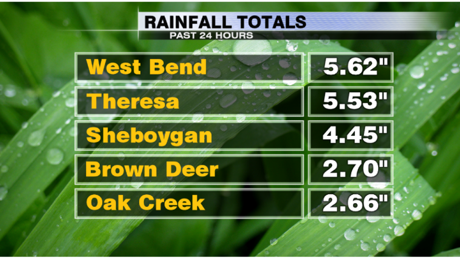
Rain totals ranging from 1" to over 5.5", this turned out to be one of our biggest rain events of the year.
The month of October is a huge time of year when it comes to transitions in the weather. The average high for the month starts at 65 degrees, and by Halloween, it is down to 53 degrees. So on Monday, Sept. 30, when temps hit a high of 87 degrees, that definitely wasn't normal.
Northern Wisconsin, of course, is first in line when it comes to peak foliage color, but now that seasonable temps are here to stay, don't be surprised if we start seeing a lot more color pop up in your neck of the woods very soon.