

New England on alert: Hurricane and Tropical Storm watches issued for much of coastline ahead of Lee's arrival
Millions of people are bracing for impacts from Hurricane Lee as the powerful Category 2 hurricane has triggered millions of residents in the U.S. to be placed under watches ahead of the arrival of tropical storm and hurricane conditions within the next 48 hours.
On Wednesday evening, Hurricane, Tropical Storm and Storm Surge watches were issued for the New England coastline and Bermuda was under a Tropical Storm Warning.
Boston is included in the Tropical Storm Watch where sustained winds could reach 39-73 mph, starting Friday evening and into the first part of the weekend.
Maine Gov. Janet Mills and the Maine Emergency Management Agency were also urging residents to start preparations in advance of Hurricane Lee’s approach at the end of the week.
"We are tracking the path of the storm and coordinating with federal and local partners to prepare for its arrival," Mills said in a statement. "We urge Maine people to exercise caution and to take common-sense steps to ensure they have all they need to stay safe as the storm draws closer moving into the weekend."
The NHC says Lee will gradually weaken as it moves into a more volatile environment of increasing wind shear, drier air and cooler waters over the next few days.
However, Lee’s massive size and expected increase in forward speed suggest the weakening process may be slow, and the storm will continue to grow in size as it spins north.
The hurricane is expected to become extratropical – meaning the storm would no longer need to draw its power from warm waters. So for the millions of people living along the coast of New England from Connecticut to Maine, the potential impacts could be more like a nor’easter during winter rather than a land-falling hurricane.
For coastal areas from Massachusetts to Maine, there is the additional risk of experiencing tropical-storm-force winds of 40 mph or greater. Large waves as high as 10-20 feet will be crashing against the shoreline and will bring the risk of beach erosion and coastal flooding.
Where is Hurricane Lee?
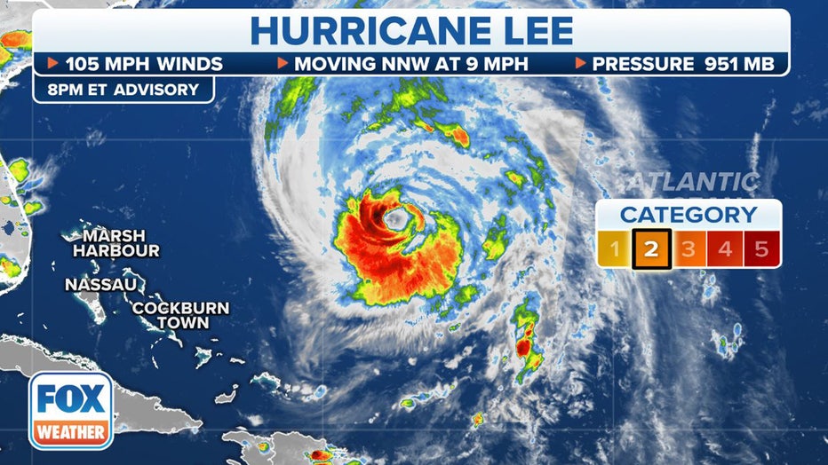
Where Hurricane Lee currently is. (FOX Weather)
As of the latest NHC advisory, Hurricane Lee is located about 420 miles south-southwest of Bermuda and about 900 miles south of Nantucket, Massachusetts. Hurricane Lee is moving to the north-northwest at 10 mph with maximum sustained winds of 105 mph, making it a Category 2 hurricane on the Saffir-Simpson Hurricane Wind Scale.
Slow weakening is forecast to begin over the next few days, but the NHC says Lee is expected to remain a large and powerful hurricane.
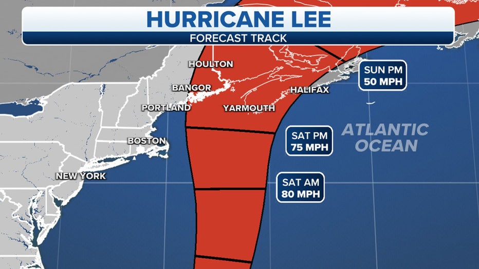
What is the forecast track for Hurricane Lee?
The NHC says Lee began to turn to the north-northwest on Wednesday, which will then be followed by a turn to the north. An increase in its forward speed also began Wednesday and will continue to increase on Thursday or Friday.
On that forecast track, the center of Lee will pass to the west of Bermuda Thursday and Thursday night. It will then approach the coast of New England or Atlantic Canada by Friday and Saturday. It's still too early to know where Lee will make landfall, although it's looking more likely that it will occur somewhere between Maine and Atlantic Canada.
Current Tropical Storm Warning in effect as Hurricane Lee nears Bermuda. (FOX Weather)
What watches or warnings are in effect due to Hurricane Lee?
The National Hurricane Center in coordination for local National Weather Services offices issued a Hurricane Watch from Stonington, Maine to the U.S.- Canada border and a Tropical Storm Watch is in effect for from Watch Hill, Rhode Island to Stonington, Maine.
Additionally, a Storm Surge Watch has been issued for communities around Cape Cod and Nantucket.
More than 7.3 million residents from Rhode Island through Maine are under a Tropical Storm Watch and Downeast Maine is under the Hurricane Watch.
The Hurricane Watch is the first type of its alert to be issued for the parts of the state's coastline in nearly 15 years.
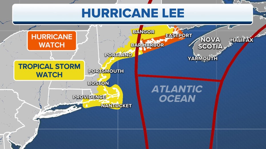
Watches and Warnings. (FOX Weather)
A watch is issued 48 hours before the anticipated first occurrence of tropical-storm-force winds or hurricane-force winds.
A Storm Surge Watch means there is a possibility of life-threatening flooding during the next 48 hours.
What will Lee's impact be in New England?
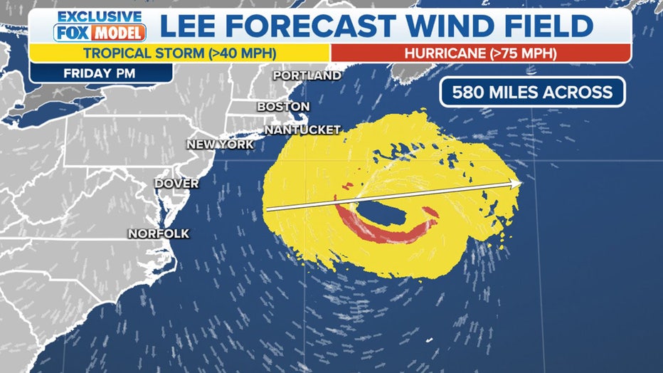
Lee's forecast wind field as it approached New England. (FOX Weather)
Hurricane Lee is expected to bring strong, possibly damaging wind gusts to the coastal regions of New England along with massive surf and heavy rain.
Lee will begin to pick up forward speed after it makes its turn to the north, and as it does so, the storm’s wind field is expected to grow in size.
The FOX Forecast Center expects Lee’s wind field to extend more than 550 miles across, which would make impacts far-reaching in New England.
HURRICANE LEE TIMELINE TRACKER: WHEN AND WHERE TO EXPECT IMPACTS IN NEW ENGLAND, MAINE
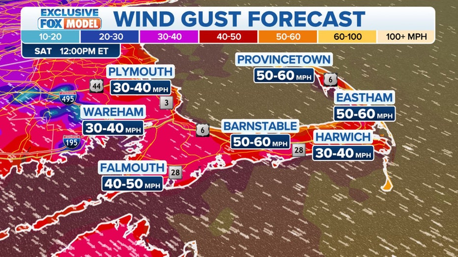
Potential wind gusts in eastern Massachusetts and Cape Cod. (FOX Weather)
Winds could be whipping across eastern Massachusetts and Cape Cod as Lee makes its move north off the coast. The strongest wind gusts will likely be felt on Cape Cod in communities such as Provincetown, Eastham, Barnstable and Harwich.
"Lee is going to start to undergo extratropical transition where it becomes less like a hurricane and more like a nor’easter, which folks up in New England are familiar with in the colder time of the year," National Hurricane Center Director Michael Brennan told FOX Weather on Monday. "So, those can be impactful storms, too. Just because it doesn’t look like a classic hurricane – nothing that gets up into this latitude is going to look like a classic hurricane. It’s going to be fast-moving, and it’s going to have hazards extending hundreds of miles from the center, regardless of the track of the center."
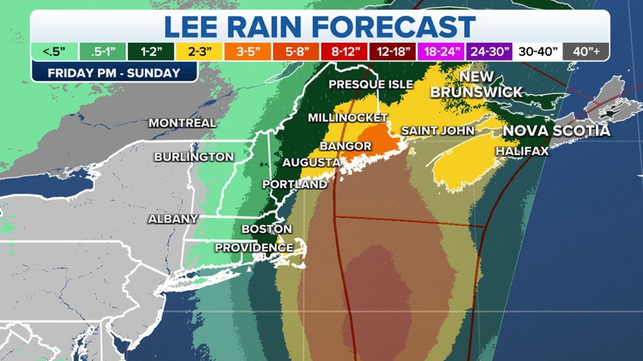
Forecast rain totals from Hurricane Lee. (FOX Weather)
Most of the heavy rain is expected to fall over Atlantic Canada, but depending on Hurricane Lee's track a few inches of rain could fall in New England.
Coastal regions from Massachusetts to Maine will see the highest rain totals, with Massachusetts, New Hampshire and most of Maine seeing about 1-2 inches, with higher amounts along coastal areas of eastern Massachusetts, including Cape Cod. Eastern Maine could also see more, with forecast totals between 2-5 inches.
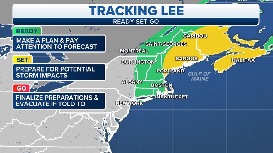
Millions of people in New England should be monitoring Hurricane Lee's progress. (FOX Weather)
People living in New England still have a day to prepare for any potential impacts Lee will have on the region, before the weather starts to deteriorate on Friday.
And while potential impacts could be seen in all parts of New England, residents along the Massachusetts and New Hampshire coasts as well as those who live in Maine should pay attention to Lee’s progress and get a plan of action ready to go.