

Sprawling Hurricane Lee's impacts begin as winds, power outages increase in New England
New England is starting to feel the impacts of Hurricane Lee as the worst of the rain, winds and coastal flooding is expected to be felt on Saturday.
While the center of the storm will likely stay east of the U.S. and move into the Canadian Maritimes, Lee's massive wind field is hundreds of miles wide and will not spare the U.S. from its wrath, according to the FOX Forecast Center.
Governors in Massachusetts and Connecticut declared states of emergency ahead of the storm and activated National Guard members to prepare for the needed response.
By late morning on Friday, winds in Massachusetts were picking up with gusts reaching around 40 mph in Nantucket. Preparations in Cape Cod were also being finalized as Gov. Maura Healey declared a state of emergency and requested assistance from the Federal Emergency Management Agency.
The National Hurricane Center dropped the Hurricane Watch for Downeast Maine while Canada extended the Hurricane Watch eastward to Ecum Secum. Tropical Storm Warnings are in effect for much of the New England Coast, spreading from the Massachusetts/Rhode Island border north into Canada, covering much of the inland areas of central and eastern Maine.
In Canada, Tropical Storm Watches are in effect for much of the coastlines of New Brunswick, Prince Edward Island and Nova Scotia.
At last report, the hurricane was less than 500 miles south-southwest of Nova Scotia or about 290 miles southeast of Nantucket, Massachusetts.
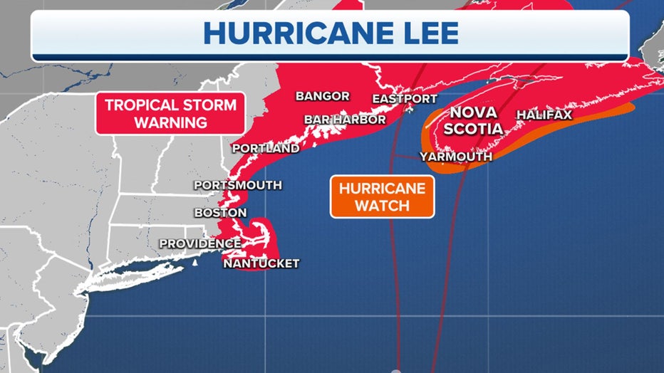
Watches and Warnings. (FOX Weather)
The current forecast has Lee making landfall likely along the western shores of Nova Scotia or perhaps the extreme southwestern corner of New Brunswick, but Lee's large size means the exact landfall location will only minimally affect the expected impacts.
"Looking at the cone, you’ll notice it’s going to be very skinny," FOX Weather meteorologist Britta Merwin said. "The impacts will be outside the cone, especially when it comes to the wind because the wind field is growing with this storm."
Coastal communities brace for rising waters from storm surge, pounding surf
The combination of storm surge and tide will cause normally dry areas near the coast to be flooded by rising waters moving inland.
About 1-3 feet of surge is expected along the coasts of Cape Cod and New England, with 1-2 feet along Long Island.
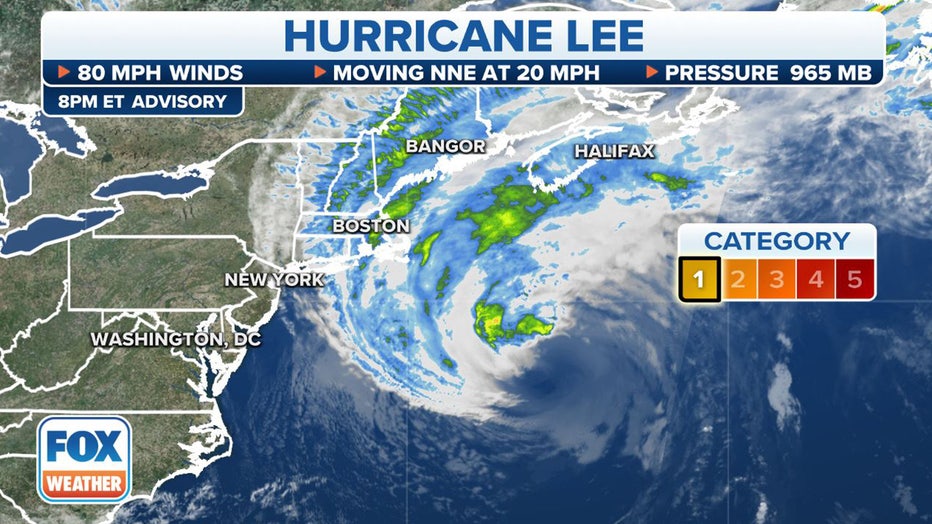
Where Hurricane Lee currently is located. (FOX Weather)
The NHC said the deepest water will occur along the immediate coast, where the surge will be accompanied by large and destructive waves – some at 10-15 feet or higher, depending on proximity to the storm.
"Some overwash is possible along much of the coast depending on the timing of the peak surge from the storm and how that coincides with the tide cycle," said FOX Weather hurricane specialist Bryan Norcross. "Water levels in Long Island Sound could reach 3 feet above the normal high tide and 2 feet on the south shore of Long Island, including on Fire Island. Besides the energy from the swells emanating from the hurricane, strong north and northeast winds Friday will push water from Long Island Sound and Great South Bay in New York into the north-facing shorelines, which could damage low-lying structures. The threat will be most pronounced at high tide."
Meanwhile, dangerous and rough surf is already hitting much of the East Coast and will continue as the Category 1 hurricane moves north offshore.
"The energy in the ocean from the broad sweep of Hurricane Lee's winds will peak along the mid-Atlantic coast (Friday)," Norcross said. "Extra-powerful waves and elevated water levels will cause beach erosion in some areas at high tide. Currents along the beaches and in inlets will be dangerously strong."
By Thursday evening, swells and rough surf were already spotted along the Southeast coasts. The Outer Banks in North Carolina saw overwash along Highway 12 more than an hour before high tide was expected.
FLORIDA COMMUNITY REPORTS FIRST FATALITY CONNECTED TO HURRICANE LEE
Hurricane Lee to bring gusts over 60 mph, rain to coastlines
People living in the warned areas of Massachusetts, New Hampshire and Maine can anticipate wind gusts of 50-65 mph along the coastline as Hurricane Lee makes its closest pass Saturday. These strong winds have the potential to cause power outages, knock down trees and create coastal flooding. Areas just a little farther inland could see wind gusts of 40-50 mph.
"For consistent tropical-storm-force winds, we’re talking about Cape Cod, Nantucket, and the stretch up toward coastal areas of Maine," Merwin said. "Once you get inland, like across Vermont and inland locations of New Hampshire, we’re talking about tropical-storm-force wind gusts."
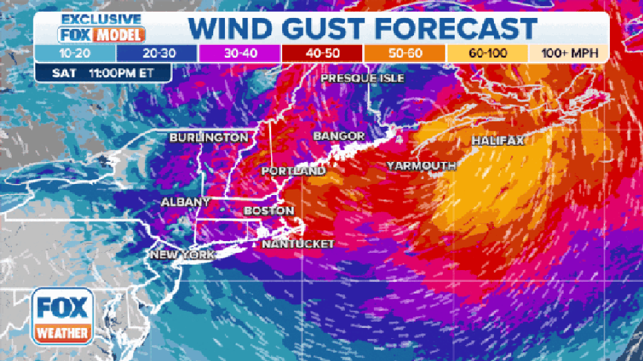
Forecast wind gusts with Hurricane Lee for Sept. 16, 2023. (FOX Weather)
With the bulk of the storm staying east of much of New England, winds will remain high but not extreme.
"Hurricane Lee will behave like a giant nor'easter, which New England should be able to deal with without too much trouble," Norcross said. "The biggest difference is that the leaves are still on the trees, which means gusty winds (could) do more damage than in the winter."
Tropical-storm force gusts are powerful enough to break branches and lead to power outages. As for Friday evening, power outages across New England topped 4,000, but there are still several hours to go before the heart of the storm arrives.
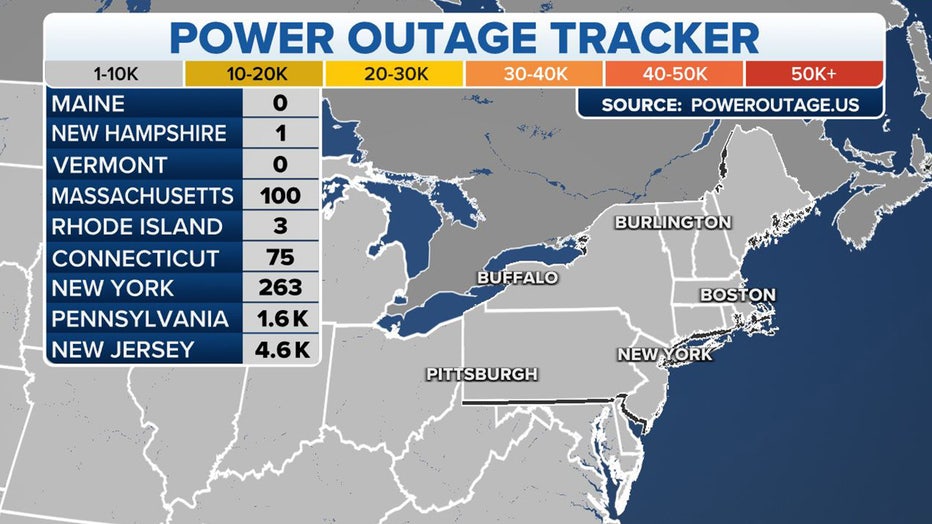
Power outage tracker. (FOX Weather)
HURRICANE LEE TIMELINE TRACKER
The storm will not produce significant flooding rains due to its forecast track and fast motion, but some places along the coast in Maine could pick up 3 to 5 inches of rain over the weekend.
Lee will quickly move through the Canadian Maritimes Sunday, allowing for rapidly improving conditions in New England Sunday. More rain returns to the Northeast on Monday as a more traditional frontal system swings through.
Hurricane Lee brings strong winds, heavy surf to Bermuda
While Lee bypassed the pink-sand beaches of Bermuda, the storm has lashed the islands with rain, wind and waves in recent days. The strong winds, with gusts of up to 51 miles per hour, caused power outages throughout the island on Thursday afternoon. Alerts in Bermuda related to Hurricane Lee were dropped Friday afternoon.