

Rare Tropical Storm Akará forms off coast of Brazil
BRASÍLIA, Brazil - A tropical storm formed off the eastern coast of Brazil on Monday.
While it’s not unheard of, the system developed in a part of the Atlantic Ocean that is usually void of tropical cyclone activity.
On Friday, the Brazilian Navy analyzed an area of low pressure that developed, and on Sunday, the Navy reported that the storm was approximately 260 nautical miles southeast of the city of Arraial do Cabo – a coastal town in the state of Rio de Janeiro.
It was first dubbed a tropical depression on Feb. 18, and that evening was named Tropical Storm Akará.
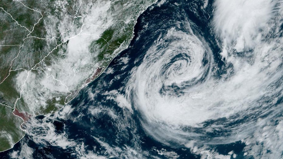
Tropical Storm Akará in the South Atlantic as seen on GOES satellite images. (Credit: NOAA)
According to NOAA's Cooperative Institute for Meteorological Satellite Studies, the system continued to organize and intensify Sunday and into Monday, eventually reaching tropical storm strength with winds greater than 40 mph.
How rare is Akará?
In short, it's very rare.
Akará is the first named system in the South Atlantic Basin since 2022. The last named system to form in this region was Subtropical Storm Yakecan.
According to NOAA, there has been only one occasion of a hurricane off the coast of South America during the modern satellite era. Hurricane Catarina made landfall in southern Brazil as a Category 1 storm on March 27, 2004.
In March 2010, Tropical Storm Anita formed off the Brazilian coast. Then, in late March 2019, Tropical Storm Iba formed in a similar location. And, in mid-February 2021, a subtropical system was characterized by NOAA as Tropical Storm 01Q.
Akará moves south
Water temperatures are estimated to be in the lower to mid-80s, which is sufficient to support tropical cyclone activity. However, the system is not expected to impact land as it slowly moves southward.
The U.K. Met Office said the "unusual" tropical storm is expected to continue moving southward and remain off the coast of southeastern Brazil.
RELATED: Extreme weather, flooding influencing where millions in US decide to live, research shows
The system brought some high surf and heavy rain to parts of South America before pushing offshore. According to the FOX Forecast Center, upper-level winds will become more hostile by midweek and put a halt to the intensification process.
Some previous model runs showed the system gaining enough organization to approach low-end hurricane status, but the window of development is fairly short, which would not allow for significant intensification.
This story was reported from Los Angeles. FOX Weather contributed.