1998 Derecho: Historic storm damage remembered 25 years later

Remembering historic 1998 derecho
Twenty-five years after it wreaked havoc, FOX6 Weather Expert Tom Wachs looks back on the 1998 derecho and explains why the damage associated with it was so severe.
MILWAUKEE - It has been 25 years since one of the most powerful lines of thunderstorms to ever hit the Midwest smacked Milwaukee and southeast Wisconsin.
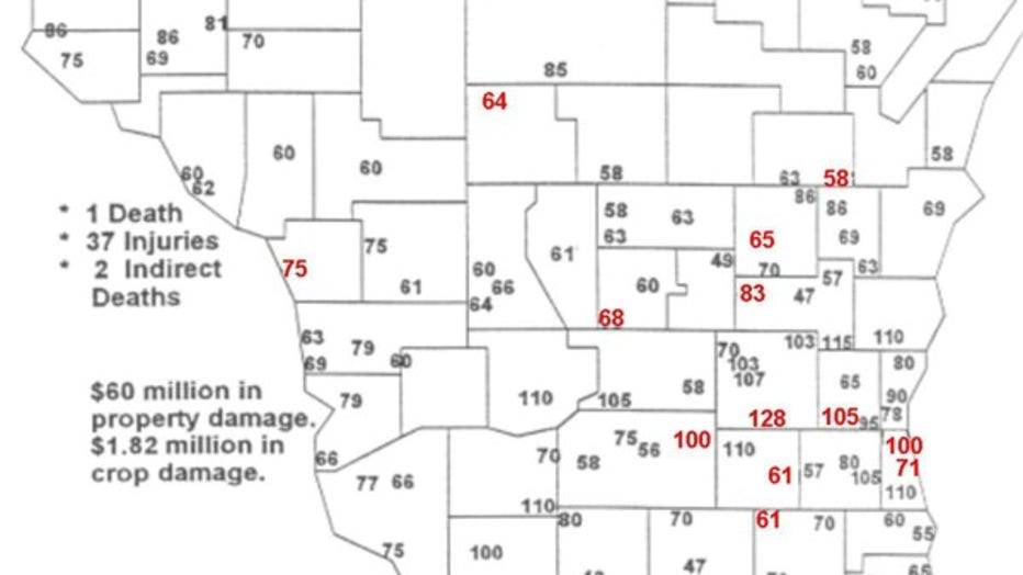
Early Sunday morning, May 31, 1998, an intense line of thunderstorms packing winds of more than 100 miles per hour (mph) moved in from the northwest. A 128 mph wind gust was reported not far from Watertown in Dodge County – and a 100 mph wind was reported in Milwaukee County (including at FOX6 in Brown Deer).
One person died from injuries suffered in the storm in Wisconsin, two indirectly. 37 people were hurt.
According to the National Weather Service (NWS), the storm caused $60 million in damage and more than $1.8 million in damage to crops. At the time, the NWS called this the most widespread and intense storm during the past 20 years.
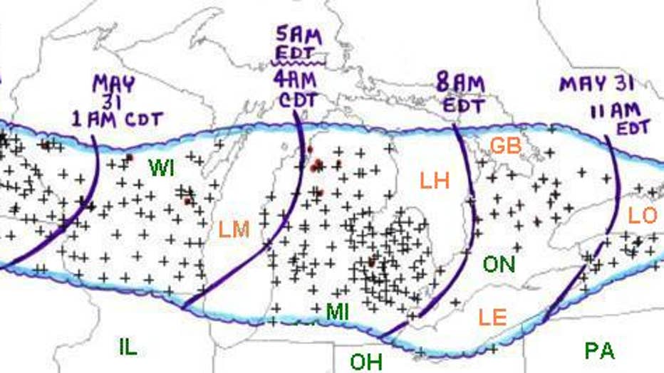
This line of storms developed late that Saturday night, May 30, in the small town of Spencer, South Dakota. An F4 tornado destroyed most of the town that evening. That was the beginning of a line of storms that would travel nearly 1,000 miles in just 15 hours.

From Storm Prediction Center. Area affected by the May 30-31, 1998 derecho event (outlined in blue). Curved purple lines represent the ap – two roximate locations of the "gust front" at three hourly intervals. "+" symbols indicate the locations of wi
A line of severe thunderstorms is called a "derecho" when it produces wind gusts of 58 mph or more for at least 240 miles. In 1998, the line of storms produced damage for 975 miles.
This was a well-forecast event, meaning an intense overnight severe weather event was expected in southeast Wisconsin. Former FOX6 Meteorologist Bart Adrian had been on-air that Saturday night warning of overnight severe weather. The storms raced through well after midnight.
The National Weather Service in Milwaukee/Sullivan was issuing warnings 25 to 45 minutes in advance of the storm.

Maximum wind gusts in mph associated with the May 30-31 derecho in Wisconsin. Measured gust values are red and estimated gust values are black [Modified version of a map prepared by National Weather Service meteorologists Rusty Kapela (Sullivan/Milwa
According to the NWS, "Residents described the powerful winds as sounding like ‘screaming freight trains,’ and couldn't believe the amount of damage in their wake.
"Overall, the damage in the worst hit areas resembled what would be generated by a lower-end F2 tornado (F2 has wind speeds of 113 to 157 mph). A series of individual downbursts with gusts to around 100 mph or more favored a corridor from southern Sauk County east/southeast to the Milwaukee area. Another favored area was across northern Dodge County through southern Fond du Lac County into southern Sheboygan and parts of Ozaukee County."
FOX6 perspective
The FOX6 Storm Center was staffed and ready for this line to come through. Former FOX6 Meteorologist Bart Adrian and Retired Chief Meteorologist Vince Condella joined forces to cover the event in the early morning hours. Here are their firsthand accounts.
Former FOX6 Meteorologist Bart Adrian
My work shift on Saturday, May 30, 1998, started with a quiet afternoon and early evening, but by 10pm a nasty thunderstorm complex was developing in south-central Minnesota and racing eastward. Between 11pm and midnight, numerous reports of thunderstorm wind gusts of 80 to 100 mph began trickling in from eastern Minnesota and western Wisconsin. Watching the storm complex continue to intensify on radar, I began to realize that this could be an extraordinary severe weather event. Between midnight and 1 a.m., wind gust reports of 100 to 110 mph arrived from counties just west of Madison.
Now I was REALLY concerned, and I took two steps I had never taken before... First, sometime toward 1 a.m., I decided to call the station news director, Jill Geisler. (As someone who did not want to over-hype a weather situation, for me to make that call was a big deal.) I told Jill I thought we needed to get everyone ready to cover a widespread and major pre-dawn wind damage event in southeastern Wisconsin. Second, around 2:30 a.m., I called my wife, and told her to wake up our little boys and go to the basement of our home. Thankfully, both my calls inspired action.
The storms reached Milwaukee and the lakeshore counties between 3 a.m. and 4 a.m. with full fury. At one point, I seriously considered leaving the weather office (which had a window) when I heard the wind outside like never before. When it calmed down, I looked out to find more than a dozen trees on the station grounds had been severely damaged, and the entire west-facing stretch of our relatively new back fence had been knocked down. Our anemometer had maxed out at 99 mph on the biggest gust, which was later estimated at 105 mph.
My colleague Vince Condella came in to relieve me shortly thereafter. I headed home just before 5:30 a.m. – an incredible 16-hour shift. For Vince, an even longer shift lay ahead with all the clean-up coverage that Sunday. My bleary-eyed drive home was amazing. Downed tree limbs were everywhere, and hardly any traffic stoplights were working due to all the power outages. When I arrived home, I was thrilled to find that, except for some lawn furniture blown about, everything was intact – especially my family.
Retired FOX6 Chief Meteorologist Vince Condella
That was quite a night. I remember driving to work at 3 a.m. to relieve Bart, who had been on duty since earlier in the day (Saturday). So this would be 3 a.m. Sunday morning. I’m driving south on Range Line Road toward Brown Deer Road in southern Ozaukee County and wind-blown branches, leaves, and debris were blowing across the road. Crazy! I walked into the weather office as Bart was completing a live on-air cut-in and the wind gust bowed the weather office window INWARD! Scared us both. Our digital anemometer on top of the studio roof peaked at 99 mph, which is high as it was able to record. So the gust was most likely higher. No question that derechos pack a punch, and can lead to a wide swath of destruction even more devastating than a tornado.

