

SE Wisconsin tornadoes confirmed; 105 mph wind speeds

Williams Bay, Walworth County
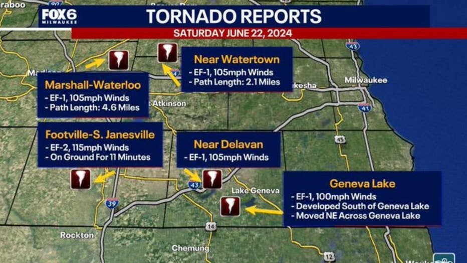
WALWORTH COUNTY, Wis. - The National Weather Service has now confirmed five tornadoes touched down in southeast Wisconsin during severe weather on Saturday, June 22.
The first touched down around 7:10 p.m. in Dane County and stayed on the ground until it lifted just south of Waterloo. The EF-1 had peak wind speeds estimated at 105 mph.
A second EF-1 tornado touched down in Watertown around 7:30 p.m., also with peak winds estimated at 105 mph.
SIGN UP TODAY: Get daily headlines, breaking news emails from FOX6 News
Two more EF-1 tornadoes were confirmed in Walworth County around 8:20 p.m. One with peak winds estimated at 105 mph touched down in Delavan, and another with peak winds around 100 mph touched down south of Geneva Lake before lifting near Lake Como.
It was not until Wednesday, June 26 that the NWS confirmed a fifth tornado in the region. An EF-0 with peak winds around 70 mph was reported in Powers Lake.
FOX6 Weather Extras
Meanwhile, FOX6Now.com offers a variety of extremely useful weather tools to help you navigate the stormy season. They include the following:

FOX6 Storm Center app
FOX6 News app
FOX Weather app
What is the FOX Model?

What is the FOX Model?
FOX Weather Expert Tom Wachs explains the value of the FOX Model for our team -- and our viewers.
FOX Weather
Maps and radar
We have a host of maps and radars on the FOX6 Weather page that are updating regularly — to provide you the most accurate assessment of the weather. From a county-by-county view to the Midwest regional radar and a national view — it’s all there.
School and business closings
When the weather gets a little dicey, schools and businesses may shut down. Monitor the latest list of closings, cancellations, and delays reported in southeast Wisconsin.

FOX6 Weather Experts in social media
- CLICK HERE to "Like" the FOX6 Weather Team on Facebook
- CLICK HERE to "Like" Rob Haswell on Facebook
- CLICK HERE to "Like" Tom Wachs on Facebook
- CLICK HERE to "Like" Stephanie Barichello on Facebook
- CLICK HERE to "Like" Lisa Michaels on Facebook
- CLICK HERE to "Follow" the FOX6 Weather Team on X
- CLICK HERE to "Follow" Rob Haswell on X
- CLICK HERE to "Follow" Tom Wachs on X
- CLICK HERE to "Follow" Stephanie Barichello on X
- CLICK HERE to "Follow" Lisa Michaels on X