

Strong winds in southeast Wisconsin this week; gust from 30-50 mph
MILWAUKEE - A second Wind Advisory has been issued for southeastern Wisconsin on Tuesday, Jan. 28 from 1PM to 6PM for winds that can gust 45 to 50 mph.
Dig deeper:
Why do we have such strong winds this week? Let us take it back to the basics.
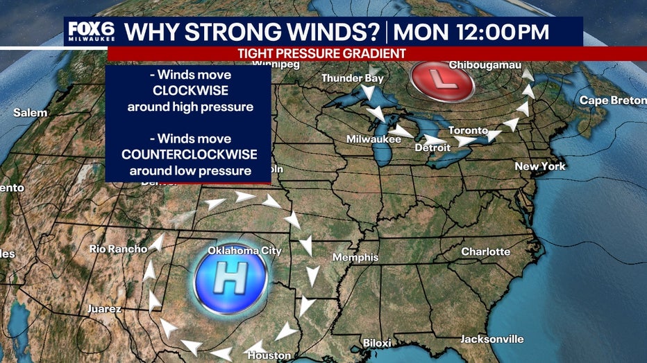
Winds move clockwise around an area of high pressure and counterclockwise around an area of low pressure.
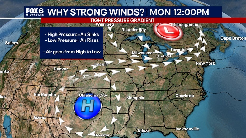
With high pressure, air sinks towards the surface, while the opposite is true with low pressure where air rises from the surface. Winds blow from high pressure to low pressure to replace the air that is rising up into the low.
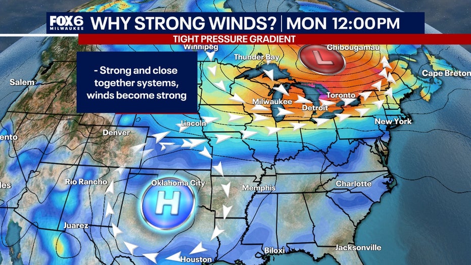
When the high pressure and low pressure are strong and relatively close together, this strengthens the winds. Take a look at the picture below and notice the black lines. These are called isobars, which represent lines of equal pressure.
SIGN UP TODAY: Get daily headlines, breaking news emails from FOX6 News
The tighter or closer the isobars (black lines), the stronger the winds. We also call this a tight pressure gradient. This is defined as a rapid change in pressure across a ‘short’ distance.
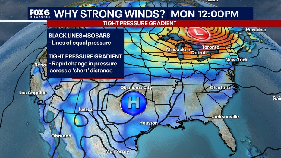
As the area of low pressure is close to Milwaukee throughout the day on Tuesday, the isobars are close together with orange colors indicating strong gusty winds. Notice how by Wednesday morning the isobars are more spaced out and the color changes to blue?
What's next:
This means as the low pressure is moving away the winds will become weaker on Wednesday. So overall, plan for windy conditions Tuesday afternoon and early evening. Winds will gradually weaken heading into Wednesday.
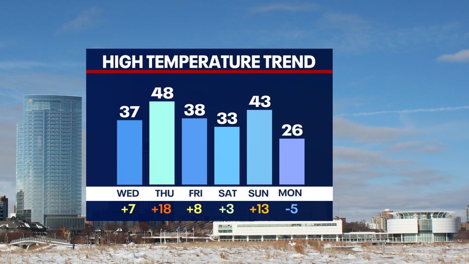
A series of low pressure systems will emerge from Canada this week, creating a wave of winds that will be strong then weakening. These strong winds will warm temperatures into the 40s for several days this week!
FREE DOWNLOAD: Get breaking news alerts in the FOX LOCAL Mobile app for iOS or Android
This will put temperatures anywhere from 5°F to 20°F above normal.
FOX6 Weather Extras
Meanwhile, FOX6Now.com offers a variety of extremely useful weather tools to help you navigate the stormy season. They include the following:
FOX6 Storm Center app

FOX LOCAL Mobile app
FOX Weather app
What is the FOX Model?
What is the FOX Model?
FOX Weather Expert Tom Wachs explains the value of the FOX Model for our team -- and our viewers.
FOX Weather
Maps and radar
We have a host of maps and radars on the FOX6 Weather page that are updating regularly — to provide you the most accurate assessment of the weather. From a county-by-county view to the Midwest regional radar and a national view — it’s all there.
School and business closings
When the weather gets a little dicey, schools and businesses may shut down. Monitor the latest list of closings, cancellations, and delays reported in southeast Wisconsin.

FOX6 Weather Experts in social media
- CLICK HERE to "Like" the FOX6 Weather Team on Facebook
- CLICK HERE to "Like" Rob Haswell on Facebook
- CLICK HERE to "Like" Tom Wachs on Facebook
- CLICK HERE to "Like" Stephanie Barichello on Facebook
- CLICK HERE to "Like" Lisa Michaels on Facebook
- CLICK HERE to "Like" Holly Baker on Facebook
- CLICK HERE to "Follow" the FOX6 Weather Team on X
- CLICK HERE to "Follow" Rob Haswell on X
- CLICK HERE to "Follow" Tom Wachs on X
- CLICK HERE to "Follow" Stephanie Barichello on X
- CLICK HERE to "Follow" Lisa Michaels on X
- CLICK HERE to "Follow" Holly Baker on X
The Source: The information in this report is from the FOX6 Weather Experts and the National Weather Service.