

Southeast Wisconsin heavy rain, severe storms return; what to expect
Weather webcast with Stephanie Barichello
Steady rain showers continue through early afternoon, then we should see at least a brief dry break. Thunderstorms may develop between 4-8 p.m.
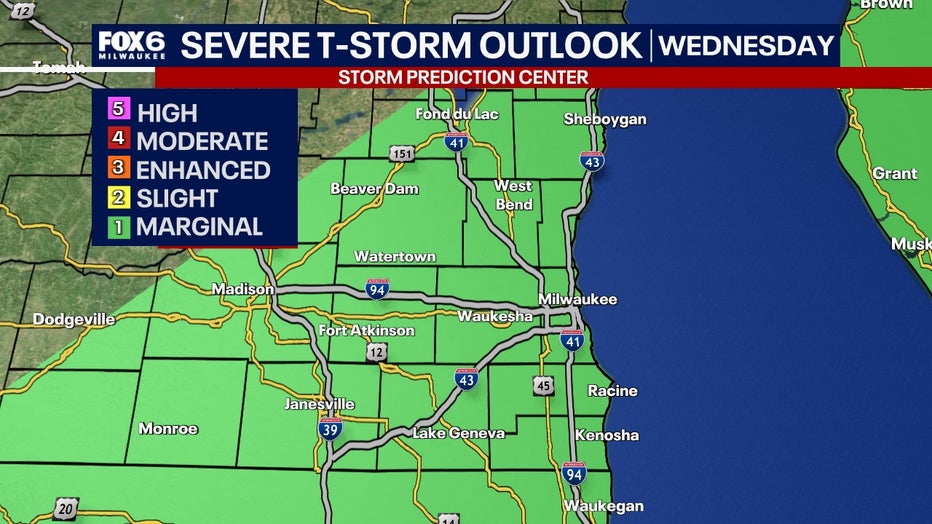
MILWAUKEE - The Storm Prediction Center has issued a risk for severe storms for Wednesday, April 2. Due to morning storms, the higher threat level for severe weather has shifted south, but southeast Wisconsin is still under a marginal risk for Wednesday afternoon.
FREE DOWNLOAD: Get breaking news alerts in the FOX LOCAL Mobile app for iOS or Android
Why you should care:
Once again, this large, impactful system will be a hard hitter for portions of the Ohio River Valley and Mississippi River Valley areas where there is a very high risk for large hail, damaging winds and large tornadoes. This type of rare, high-risk event is typically only issued once or twice a year.
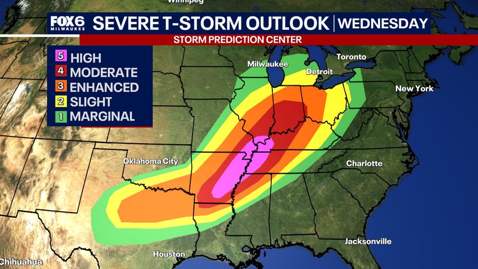
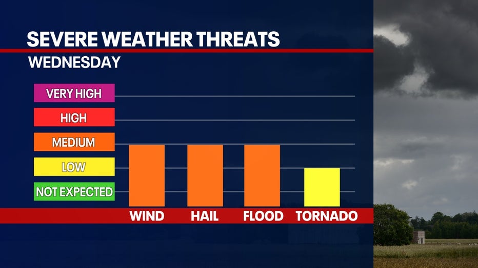
The threats increase during Wednesday afternoon and evening. Chances for damaging winds, large hail, heavy rain and tornadoes are possible – that is, if storms can develop and survive.
This will be a tricky setup dependent on how morning convection goes. If the morning rain and storms move out faster, this will allow the atmosphere to recover and raise the threat for severe weather in the afternoon. If the morning rain and storms linger further into the late morning and afternoon, this can lower the period for severe weather to be possible in the afternoon and evening. Either way, it is best to be weather-ready heading into Wednesday.
Snow chances
Why you should care:
SIGN UP TODAY: Get daily headlines, breaking news emails from FOX6 News
Strong winds will accompany this sytem all day with gusts of 30 mph to 40mph. Where the warm front sets up this afternoon, temperatures, dew points and energy in the atmosphere are all factors that will determine how storms will thrive Wednesday mid to late afternoon.
While Skyvision is indicating some storms to pop, they are likely to weaken heading towards Lake Michigan. We still could have some heavy rain, strong winds and hail as the main threats. The tornado threat remains very low for today.
Be weather-ready all day Wednesday and keep your devices charged. Your FOX6 Weather Experts will have you covered and keep you up to date with the latest information.
FOX6 Weather Extras
Meanwhile, FOX6Now.com offers a variety of extremely useful weather tools to help you navigate the stormy season. They include the following:
FOX6 Storm Center app

FOX LOCAL Mobile app
FOX Weather app
What is the FOX Model?
What is the FOX Model?
FOX Weather Expert Tom Wachs explains the value of the FOX Model for our team -- and our viewers.
FOX Weather
Maps and radar
We have a host of maps and radars on the FOX6 Weather page that are updating regularly — to provide you the most accurate assessment of the weather. From a county-by-county view to the Midwest regional radar and a national view — it’s all there.
School and business closings
When the weather gets a little dicey, schools and businesses may shut down. Monitor the latest list of closings, cancellations, and delays reported in southeast Wisconsin.

FOX6 Weather Experts in social media
- CLICK HERE to "Like" the FOX6 Weather Team on Facebook
- CLICK HERE to "Like" Rob Haswell on Facebook
- CLICK HERE to "Like" Tom Wachs on Facebook
- CLICK HERE to "Like" Stephanie Barichello on Facebook
- CLICK HERE to "Like" Lisa Michaels on Facebook
- CLICK HERE to "Like" Holly Baker on Facebook
- CLICK HERE to "Follow" the FOX6 Weather Team on X
- CLICK HERE to "Follow" Rob Haswell on X
- CLICK HERE to "Follow" Tom Wachs on X
- CLICK HERE to "Follow" Stephanie Barichello on X
- CLICK HERE to "Follow" Lisa Michaels on X
- CLICK HERE to "Follow" Holly Baker on X
The Source: Information in this report is from the FOX6 Weather Experts and National Weather Service.